
On the coastal road connecting central Côn Đảo with Bến Đầm Port, Bãi Nhát is one of Côn Sơn Island’s distinctive beaches. With no rows of shops or large resorts, it draws visitors with white sand, natural rocky shores, blue water and the outline of Love Peak rising in the distance.
What makes Bãi Nhát especially interesting is that its sand is not always clearly visible. At high tide, much of the beach may lie underwater. Only as the tide recedes does the white sand gradually emerge, opening up a space between the foot of the mountains and the sea.
Bãi Nhát is also known as one of Côn Đảo’s scenic sunset spots. On clear afternoons, the last sunlight spreads across the water, with Love Peak in the distance, creating a view that makes many visitors want to linger.
Beyond its natural beauty, the Bãi Nhát area is associated with a significant historical event: the escape attempt on 12 December 1952 by 198 prisoners sentenced to hard labour during French colonial administration of Côn Đảo Prison.
Where is Bãi Nhát in Côn Đảo?
Bãi Nhát lies in the south and southwest of Côn Sơn Island, within the Côn Đảo Special Zone, Ho Chi Minh City.
The beach is around 6 km from central Côn Đảo, on the road to Bến Đầm Port.
From the centre, follow the coastal road towards Mũi Cá Mập and Bến Đầm. Many stretches hug the hillsides, with green vegetation on one side and broad sea views on the other.
Bãi Nhát lies beneath coastal hillsides, not far from Mũi Cá Mập. From here, visitors can see Hòn Bà and the outline of Love Peak on the horizon.
Unlike beaches in residential areas, Bãi Nhát has few tourist facilities. Its scenery is shaped mainly by mountains, sea, sand and natural rocks scattered along the shore.
This simplicity is part of Bãi Nhát’s appeal, especially for those who enjoy exploring nature and landscape photography.
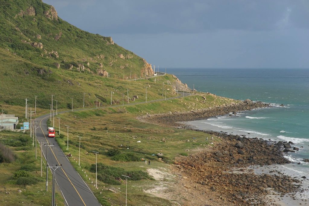
Why does Bãi Nhát emerge at low tide?
Bãi Nhát’s most distinctive feature is the way its scenery changes with the tide.
When sea levels rise, many sandy areas are covered. From the road above, visitors may see only water, bands of waves and rocks close to the foot of the mountains.
As the tide recedes, the sand begins to appear. The water retreats, leaving damp sand, rocky stretches and small rivulets along the shoreline.
At this point, Bãi Nhát looks very different from its high-tide appearance.
White sand emerging between mountains and sea
When the tide drops low enough, a strip of white sand appears beneath the mountains.
The sand is relatively fine, interspersed with pebbles and boulders. Stones of different shapes and sizes scattered along the beach give the shoreline its character.
On sunny days, wet sand reflects the light, making the beach look brighter. The sea may appear turquoise or blue, depending on the weather and viewpoint.
The fairly open space and limited construction allow visitors to appreciate the area’s natural scenery.
Does Bãi Nhát emerge at a fixed time each day?
No. When the sand becomes exposed depends on the tidal cycle, not on a fixed time of day.
On some days, low tide occurs in the morning; on others, it may fall around midday or in the afternoon.
The extent of exposed beach also varies. A lower tide reveals more sand, while a smaller drop may leave only a narrow strip visible.
If you want to take photographs on the sand, check the tide forecast for Côn Đảo before visiting.
An important point: A beautiful sunset does not necessarily coincide with exposed sand. To enjoy both sunset views and a walk on the beach, choose a day when low tide aligns suitably with sunset.
The natural beauty of Bãi Nhát
Natural rocks along the shore
One of Bãi Nhát’s characteristic sights is its rocks scattered across the sand or close to the water’s edge.
Some large boulders stand alone, while others form clusters shaped by waves over time.
At high tide, waves break around the boulders in bands of white foam. At low tide, the rock surfaces become clearer, interspersed with pale sand.
Towards the end of the day, the rocks become striking foreground features against the sea reflecting the sunset.
These details make Bãi Nhát particularly suited to landscape photography. A change in position or camera angle can produce many different compositions.
However, rock surfaces may be slippery because of seaweed, algae or seawater. Move carefully, especially as the tide rises.
Green hillsides close to the sea
Behind Bãi Nhát rise the hillsides characteristic of Côn Sơn Island.
Much of the terrain is steep, with forest growing almost to the shore. Viewed from the road above, the sand lies between the hillsides and the wide blue sea.
The combination of mountains, rocks and sea gives Bãi Nhát a different character from flat mainland beaches.
From elevated viewpoints, visitors can also see the shoreline curving around the foot of the mountains and the coastal road in the distance.
A peaceful setting on the Bến Đầm road
Bãi Nhát has few entertainment services along the shore.
For some visitors, this may be a limitation. For those who enjoy scenery and nature, the quietness is precisely its appeal.
Simple activities such as listening to the waves, watching the horizon or taking a few photographs can become memorable experiences.
However, Bãi Nhát is beside the road to Bến Đầm Port, so vehicles still pass by. Choose suitable places to stop and park without compromising road safety.
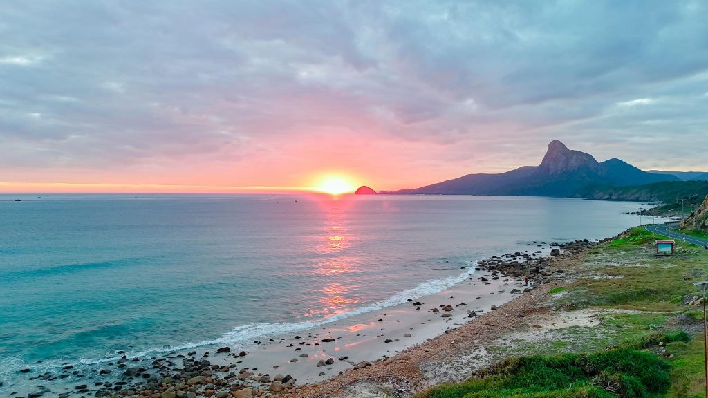
Sunset at Bãi Nhát: one of Côn Đảo’s beautiful scenes
If choosing a time to view Bãi Nhát from above, the afternoon is worth considering.
The beach lies in the southwest of Côn Sơn Island, looking out over the sea and distant mountains.
As the sun drops, the light begins to soften. The sea changes from blue to shades of yellow, orange and pink, depending on the clouds and atmospheric conditions.
Rocks near the shore darken while patches of damp sand reflect the last light of the day.
In the distance are the shape of Love Peak and the outline of Hòn Bà.
Watching the sunset from the sand
If the tide is receding and access is safe, visitors can watch the sunset from sandy stretches along the shore.
This viewpoint brings you closer to the changing water and the small waves continually reaching the beach.
However, keep track of when the tide will rise again. Do not venture too far or remain on the beach after dark.
Watching the sunset from the coastal road
At high tide, visitors can still enjoy the scenery from safe viewpoints above the beach.
The coastal road offers a broad view of Bãi Nhát, the hillsides and Hòn Bà in the distance.
This may also be a more suitable option for families with young children, older visitors or anyone who prefers not to walk over rocks.
Do not stop vehicles on bends, narrow stretches or places with restricted visibility.
Love Peak: a distinctive landmark seen from Bãi Nhát
Looking towards Hòn Bà from Bãi Nhát, visitors can see mountain peaks forming a very distinctive outline.
This is the area known as Đỉnh Tình Yêu, or Love Peak, a familiar feature of southwestern Côn Đảo’s landscape.
In local imagination, the two peaks resemble a man and woman standing together.
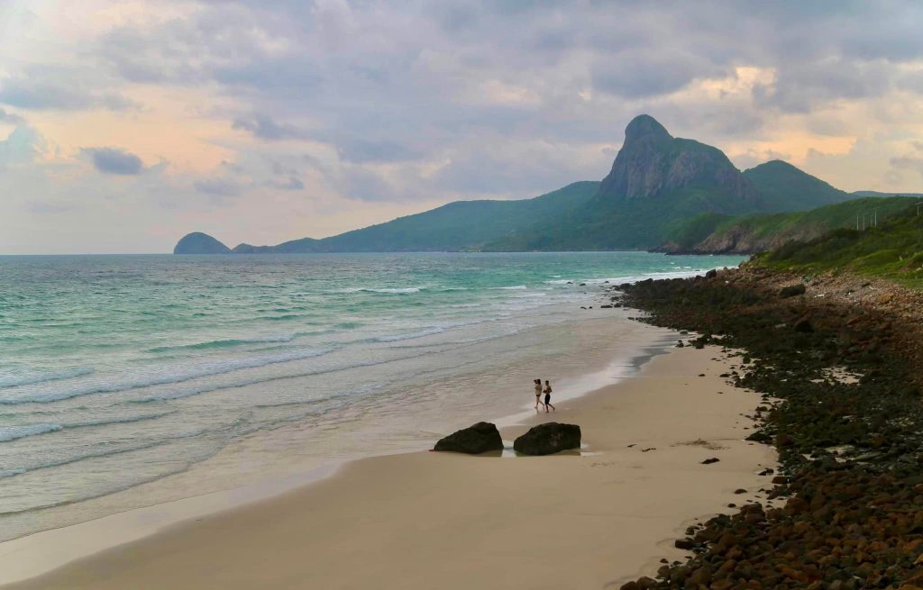
The legend of Love Peak
A local folk tale tells of a young couple whose families opposed their relationship because of their different circumstances.
Unwilling to separate, they fled together to Bến Đầm. There, they embraced and turned to stone, becoming the mountain formation later known as Love Peak.
This is a folk legend associated with the local landscape, not a verified historical event.
Even so, the story adds an interesting cultural dimension to the mountains and sea around Hòn Bà.
Today, Love Peak appears in many photographs taken from Bãi Nhát and Mũi Cá Mập.
For photography enthusiasts, it is a natural landmark that makes Côn Đảo’s scenery recognisable.
Bãi Nhát and traces of the 1952 prison escape
Alongside its natural scenery, Bãi Nhát and the road to Bến Đầm are connected with an important event in the history of Côn Đảo Prison.
During French colonial administration of the prison, many prisoners were forced to work on roads and other construction projects on the island.
The road to Bến Đầm is one of the places associated with those years of hard labour.
The escape attempt on 12 December 1952
On the night of 12 December 1952, 198 prisoners sentenced to hard labour carried out an organised escape attempt.
In preparation, they secretly built simple wooden boats and concealed them while waiting for an opportunity to escape by sea.
The escape took place in extremely difficult conditions. After leaving shore, the group faced waves, wind and adverse weather.
According to historical information recorded at the memorial site, the attempt failed. Of the 198 participants, 81 died at sea and 117 were recaptured.
Although it did not achieve its aim, the escape remains a significant event reflecting the Côn Đảo prisoners’ desire for freedom and determination to resist.
The memorial to the 198 escaping prisoners
A memorial stele to the 1952 escape stands along the road near Bãi Nhát.
It marks the historical event and commemorates those who took part, including those who died at sea.
Today, visitors travelling along the Bến Đầm road can stop at the memorial to learn about this history.
If you have time, it is a meaningful stop before or after visiting Bãi Nhát.
Maintain a respectful manner, keep noise down and avoid inappropriate photography at the memorial.
Things to experience at Bãi Nhát, Côn Đảo
Walking on the sand at low tide
This is Bãi Nhát’s most characteristic experience.
When the tide falls far enough, visitors can observe the exposed sand, natural rocks and small pools of water left behind.
Walking along the beach at this time reveals details that are difficult to see at high tide.
Wear sandals or shoes suitable for rocky ground, and avoid walking barefoot where there are shells or sharp stones.
Photographing the sea, mountains and sunset
Bãi Nhát offers many natural elements for photography.
For landscape shots, you can use rocks in the foreground, the sea as the main space and Love Peak in the distance.
If photographing towards the end of the day, arrive early to choose a position and watch the changing light.
Photographs taken before sunset often show the colours of the sea and terrain clearly. After the sun disappears, the sky may retain attractive colours for a short time.
Learning about the shoreline and tides
Bãi Nhát is a useful place to observe how the coast changes with the water level.
The same spot can look markedly different at two different times of day.
As the tide recedes, sandy and rocky areas are exposed. As it rises, these places become part of the shallow coastal water again.
This can be an interesting experience for families with children who enjoy nature. Adults must supervise them and prevent them from going onto the beach independently or approaching deep water.
Combining the visit with a historic site
Visitors interested in history can combine Bãi Nhát with the memorial to the 1952 escape.
One offers Côn Đảo’s natural scenery today; the other preserves traces of a difficult period in its history.
Together, they make the journey about more than landscape photographs.
Can you swim at Bãi Nhát?
Bãi Nhát has beautiful seawater, but it is not always suitable for swimming.
The beach is directly affected by tides, waves and weather. Some areas are rocky, have changing seabed conditions or become slippery.
It is also not a beach with the permanent services and lifeguards found at organised tourist swimming areas.
Visitors should therefore prioritise sightseeing, photography and walking in safe places.
If you want to enter the water, assess the actual conditions carefully. Do not swim far from shore or alone, and avoid rough seas or rapidly changing tides.
Families with young children and non-swimmers should not treat Bãi Nhát as their main swimming destination.
When should you visit Bãi Nhát?
Bãi Nhát can be visited year-round, but the experience depends heavily on the weather and tides.
For sightseeing, clear days with little rain and good visibility are usually more favourable.
To see the white sand clearly, choose a time when the tide is low.
For sunset photography, check the sunset time for your visit and arrive around 30–60 minutes beforehand to find a safe position.
Should you visit Bãi Nhát during the northeast monsoon?
During the northeast monsoon, wind and wave conditions around Côn Đảo can change considerably.
Bãi Nhát may still look beautiful on some days, but strong winds make walking over rocks, going down to the beach or approaching the water’s edge more dangerous.
Check the forecast before setting out and do not force your way onto the beach when waves are high.
Is Bãi Nhát more beautiful at sunrise or sunset?
Bãi Nhát is better known for sunset viewing because of its location and southwestern outlook.
This does not mean mornings are unattractive. On clear days, daylight shows the blue sea and shoreline rocks clearly.
If you want photographs of the sand, low tide matters just as much as attractive light.
How to reach Bãi Nhát, Côn Đảo
From central Côn Đảo
From the centre, head towards Bến Đầm Port.
The road follows the southern coast of Côn Sơn Island, passing Mũi Cá Mập before continuing towards Bến Đầm.
Bãi Nhát is about 6 km from the centre and can be reached conveniently by motorbike, taxi or hired car service.
Along the way, visitors can see rocky mountains close to the sea, bends around hillsides and broad views of the water.
Getting to Bãi Nhát by motorbike
A motorbike suits visitors who want the flexibility to stop for scenery along the Bến Đầm road.
However, the route has bends and steep sections. In strong winds, riders should slow down and watch for other vehicles.
Do not stop in the middle of the road, on blind bends or where stopping is prohibited.
If you want to go down to the beach, find a legal parking place first, then assess the terrain and choose a safe approach.
Getting to Bãi Nhát by taxi or hired car
For families with older people or young children, or visitors unfamiliar with winding coastal roads, taxis and hired cars are convenient options.
A single outing can combine Bãi Nhát with Mũi Cá Mập, the 1952 escape memorial and Bến Đầm Bay.
If you plan to watch the sunset, agree on a return pickup time with the driver before getting out.
A suggested itinerary for Bãi Nhát and the Bến Đầm coastal road
An afternoon is a suitable amount of time to explore Bãi Nhát and nearby places.
14:30 – Depart from central Côn Đảo
Follow the coastal road towards Bến Đầm, taking in the hillsides, sea and natural scenery along the way.
15:00 – Stop for views at Mũi Cá Mập
Photograph the sea, rocky headlands and distant islands from a safe position.
15:30 – Visit the 1952 escape memorial
Spend time at the memorial and learn about the historical event associated with the Bến Đầm road.
16:00 – Explore Bãi Nhát
Arrive at the beach area, check the tide and choose a place for photographs.
If the tide is receding, explore the sand and natural rocks in areas that are safe to access.
17:00 – Watch the sunset
Take time to watch the evening light over the sea and the outline of Love Peak.
Adjust sunset viewing times to the season and the actual sunset time.
After sunset – Return to the centre
Finish the trip before it becomes too dark.
For a more detailed look at Bến Đầm Port and fishing activities, set aside additional time rather than fitting too many places into one afternoon.
Places near Bãi Nhát to include in your visit
Mũi Cá Mập
Mũi Cá Mập, or Shark Cape, lies on the same coastal route as Bãi Nhát.
It is known for rocks projecting into the sea, expansive views and natural rocky mountain scenery.
From here, visitors can see part of Côn Sơn Island’s southern shoreline and the offshore islands.
Bến Đầm Bay
Bến Đầm Bay lies farther to the southwest of Côn Sơn Island.
Unlike Bãi Nhát, the Bến Đầm area is characterised by port operations, fishing boats, cargo vessels and high-speed ferries.
Visitors can combine views of the bay with learning about local livelihoods connected to the sea.
Hòn Bà and Love Peak
Hòn Bà is one of the larger islands in the Côn Đảo archipelago, near Bến Đầm.
It has forested mountain scenery and natural ecosystems of conservation value.
Love Peak on Hòn Bà can be seen from Bãi Nhát. To explore Hòn Bà itself or join a trek, visitors must register for a programme that complies with Côn Đảo National Park regulations.
The memorial to the 198 escaping prisoners
The memorial stands near the road to Bến Đầm and is associated with the escape attempt of 12 December 1952.
It is a meaningful stop for visitors interested in Côn Đảo’s history, alongside the well-known prison camps and historic sites in the centre.
Important tips for visiting Bãi Nhát
Check the tides: To walk on the sand, check low-tide times. Do not go down to the beach when the tide is rising rapidly.
Watch for slippery rocks: Bãi Nhát has many boulders, some covered with seaweed and algae. Avoid climbing wet rocks or standing close to breaking waves.
Do not swim in unsafe conditions: There are no permanent lifeguards. Take particular care with waves, currents and water depth.
Protect the environment: Do not leave rubbish, plastic bottles or food on the shore.
Keep a safe distance from traffic: When photographing from the coastal road, do not stand in the carriageway or stop vehicles in dangerous places.
Do not stay too late: Hillsides, rocky areas and coastal roads can be difficult to see after dark.
Respect historic sites: At the 1952 escape memorial, behave with the dignity appropriate to its significance.
Travelling to Côn Đảo by high-speed ferry to explore Bãi Nhát
For visitors travelling by sea, Bãi Nhát is a convenient place to include in a Côn Đảo itinerary.
In particular, if your high-speed ferry arrives at Bến Đầm Port, the road journey to the centre may follow the route near Bãi Nhát and Mũi Cá Mập.
However, check the arrival port on your ticket, as different ferry routes use different port locations in Côn Đảo.
If you arrive during the day and have time, you can arrange a sightseeing stop on the way to your hotel, provided your transport arrangements and route allow it.
Another option is to set aside an afternoon for Bãi Nhát, sunset viewing and nearby destinations.
When planning a trip to Côn Đảo, visitors should:
- Check high-speed ferry schedules and ticket availability.
- Confirm the exact arrival port.
- Follow the weather forecast before the trip.
- Book transfers in advance if needed.
- Allow extra time in case sea conditions cause changes to ferry schedules.
Information on ferry routes, vessels, reference fares and Côn Đảo travel guidance is available from Con Dao Express – https://condaoexpress.com.
Frequently asked questions about Bãi Nhát, Côn Đảo
How far is Bãi Nhát from central Côn Đảo?
Bãi Nhát is around 6 km from central Côn Đảo, along the coastal road to Bến Đầm Port. You can reach it by motorbike, taxi or hired car.
Why does Bãi Nhát emerge at low tide?
Bãi Nhát’s shoreline is strongly affected by tides. At high tide, much of the sand is submerged; as the water recedes, the white sand and rocks become more visible.
When is Bãi Nhát most beautiful?
Bãi Nhát is famous for sunsets, but to see a broad sandy beach you should also check low-tide times. The two do not always coincide.
Is there an entrance fee for Bãi Nhát?
Sightseeing from public viewpoints along the Bến Đầm road generally does not require a separate entrance ticket. Visitors must still comply with parking and beach-access regulations.
Can you swim at Bãi Nhát?
Bãi Nhát has beautiful water but is affected by tides, waves and rocky terrain. With no permanent lifeguards, visitors must take particular care, avoid swimming far from shore and stay out of the water when conditions are unsafe.
Can you see Love Peak from Bãi Nhát?
Yes. Looking towards Hòn Bà from Bãi Nhát, you can see the outline of Love Peak, one of southwestern Côn Đảo’s distinctive mountain landscapes.
How is Bãi Nhát connected with the history of Côn Đảo Prison?
The Bãi Nhát area and the Bến Đầm road are associated with the escape attempt by 198 prisoners sentenced to hard labour on 12 December 1952. A memorial to the event now stands near the road.
Can you combine Bãi Nhát with Bến Đầm Port?
Yes. They lie along the same coastal route. One outing can include Mũi Cá Mập, Bãi Nhát, the escape memorial and Bến Đầm Bay.
Bãi Nhát: where nature and history meet
Without large resort developments or noisy recreation, Bãi Nhát retains its distinctive beauty through changing tides, rocky shores and sunset views towards Love Peak.
Each visit may reveal a different scene. Sometimes the sea covers the sand; at other times, a white shoreline emerges in the sunlight. On clear afternoons, sunset makes the coast, boulders and mountains stand out.
But Bãi Nhát offers more than scenery. Traces of the 1952 escape remind visitors of a painful yet resilient chapter in Côn Đảo’s history.
If you want to discover both Côn Đảo’s natural beauty and its memorable historical stories, Bãi Nhát is well worth including in your itinerary.
Con Dao Express – Connecting the mainland and Côn Đảo
Website: https://condaoexpress.com
Google Maps: Bãi Nhát, Côn Đảo
The map marks Bãi Nhát on Bến Đầm Road. Check tides and weather, and park only where permitted before going down to the beach.